Environmental Monitoring with Remote Sensing
Applications of satellite imagery to track microbial water quality
Environmental Monitoring with Remote Sensing
Remote sensing is a developing method of satellite-driven data collection. This technique is primarily used in scenarios where traditional data collection is inefficient, dangerous, or costly.
Our lab is examining the potential applications of satellite imagery to detect water quality.

Published Papers
A/B (n = 56).
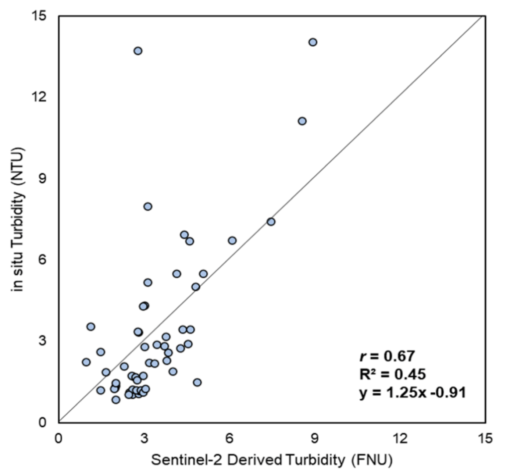
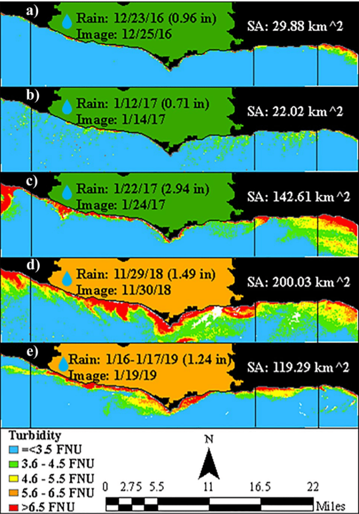
Monitoring Coastal Water Turbidity Using Sentinel2—A Case Study in Los Angeles
Remotely sensed datasets are increasingly being applied toward improved detection of water quality by augmenting monitoring programs with spatially intensive and accessible data. This study evaluates the potential of satellite remote sensing to augment traditional monitoring by analyzing the relationship between in situ and satellite-derived turbidity data.
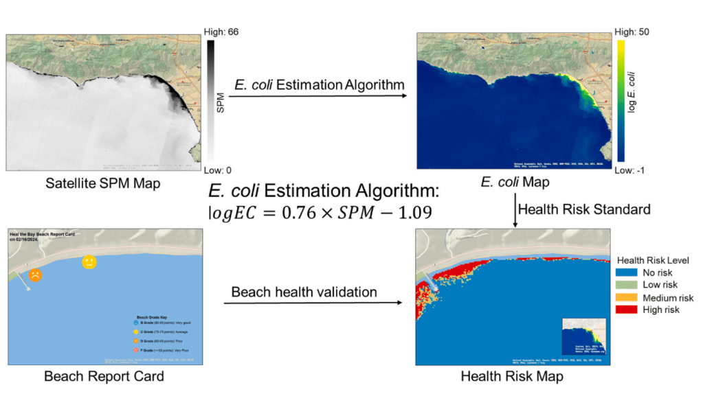
Satellite-empowered public health: Mapping coastal fecal contamination risks through Sentinel-2 imagery
While remote sensing has been widely adopted for assessing physicochemical water quality parameters, its application to microbial indicators remains limited. To evaluate the feasibility of integrating satellite observations into microbial water quality assessments, this study investigated the hypothesis that satellite derived suspended matter concentrations predict levels of fecal indicator bacteria, Escherichia coli (E. coli), which are linked to human health through epidemiological studies.

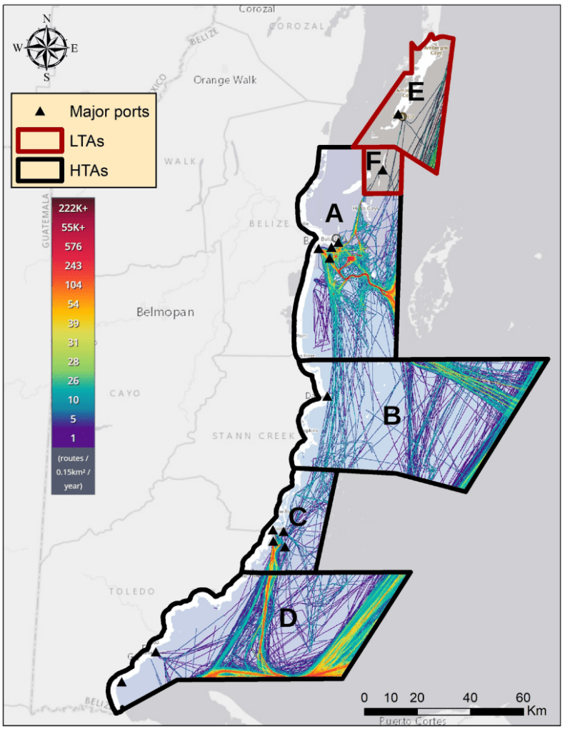
A GEE toolkit for water quality monitoring from 2002 to 2022 in support of SDG 14 and coral health in marine protected areas in Belize
In order to conserve their marine ecosystems, Belize has a network of Marine Protected Areas (MPAs) throughout their coastal waters. Using Aqua MODIS satellite imagery from 2002 to 2022, Google Earth Engine, and RStudio, we present a workflow to calculate stress days on MPAs and a coral vulnerability index based on sea surface temperature (SST) and Kd (490), a proxy of water clarity.
Effect of COVID-19 Anthropause on Water Clarity in the Belize Coastal Lagoon
The Coronavirus disease 2019 (COVID-19) pandemic halted human activities globally in multiple sectors including tourism. As a result, nations with heavy tourism, such as Belize, experienced improvements in water quality. Remote sensing technologies can detect impacts of “anthropauses” on coastal water quality. In this study, moderate resolution imaging spectroradiometer (MODIS) satellite data were employed along the Belizean coast to investigate impacts of the COVID-19 shutdown on water quality.
Turbidity and fecal indicator bacteria in recreational marine waters increase following the 2018 Woolsey Fire
Wildfires increase runoff and sediment yields that impact downstream ecosystems. While the effects of wildfire on stream water quality are well documented, oceanic responses to wildfire remain poorly understood. Therefore, this study investigated oceanic responses to the 2018 Woolsey Fire using satellite remote sensing and in situ data analyses.
